Much to my dismay, I had no internet connection last night, so this post is really January 3rd. I thought my Verizon aircard, now connected to my antenna and amplifier, would not fail me. Alas, I was wrong.
I have many pictures to show you today and I have saved the best for last, so I hope you stay with me.
I have many pictures to show you today and I have saved the best for last, so I hope you stay with me.
 Chorro begged to drive as we left Shepard State Park, but I do love to drive myself and, being older, bigger, and human, I won out.
The Park attendant told us about a campground on Dauphin Island that we will try to find. It is about an hour to the east. On the way, we crossed the Singing River, named for the time when the Pascagoula Indian tribe chose to walk, holding hands and singing, into the river rather than be taken captive by their enemies. 
A little farther on, we crossed an inlet of the Mississippi Sound with a draw bridge and lots of sailing vessels.

There was an old Spanish Fort built in 1715 in Gautier, Mississippi, that we stopped to look at. It had walls about two feet thick that were built with mortar and oyster shells. I was disappointed that it didn't look more "Spanish," but I guess it IS Spanish and my expectations were something else.

Katrina has wreaked her havoc here in Gautier too, and many of the old monuments and tombstones in this graveyard beside the fort are now piles of rubble.

 We found a great spot to eat lunch and cavort on the sandy beach. (One of us ate lunch, one of us cavorted on the sandy beach.) Can you spot Chorro on the white sand in the second picture?
 These trees were draped with Spanish moss that has died. Katrina's influence, I suppose.
One last interesting sight by the fort was this Christmas scene. The best part is the "Christmas tree" towering over.

On the way again, and there is Dauphin Island in the distance.

We drove over a long causeway and a bridge on the way over. The water with the sun sparkling on it was so beautiful.

These houses are prepared for the next flood, up to ten feet. And the little palm trees are prepared for the same depth, as well.

Dauphin Island's main street welcomes us.

I expected a state park campground on Dauphin Island, but that was not to be. So we stayed in our first "RV Park."

After we get settled in and leveled, the deal is that I can quickly grab my camera and then it is Chorro's time to lead. He dragged me off around the park until we saw a sign that said "GULF." Well, okay, that appealed to us both. Down the trail, we found this amazing white sand beach.


Here's the wandering wonder dog seen in the golden glory of the setting sun.

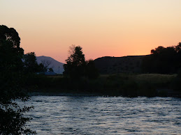
And, be still my heart, an opportunity to photograph one more beautiful sunset, this one on the Gulf of Mexico.


For me, that was an opportunity of a lifetime and moments to treasure forever.
And tomorrow is a new day.
4 comments:
The sand along the gulf shore is really interesting stuff. I have never been to the northern part of the Gulf, but both east and west. The sand varies by location, sometimes riddled with shells, and other times pure and clean.
Looks nice down there, hope the weather is warming up!
The beach and white sand with the old gnarly tree made for some excellent sunset pictures--sure made me lonely for the coast (west, that is).
Geno said to tell you you're going the wrong way if you want to make it to the southwest! I told him you were a curvy line, not a straight line! Enjoy the ocean--find any neat shells?
I meant TRAVELING a curvy line
It's going to be 75 here on Sunday, does that mean you are coming back? Emily and her husband, Murphy, both asked about you today. I told them you were in search of warmer weather.
HUGS
Post a Comment