Tuesday, December 30, 2008

From Mississippi to Texas

The Mississippi River forms the entire western boundary of the state of Mississippi and can only be crossed at three places .The Greenville crossing is in the north between Mississippi and Arkansas and the Vicksburg and Natchez crossings are between Mississippi and Louisiana. Chorro and I have now crossed at all three places.

Greenville--

Vicksburg (we did this crossing last year)--


and here we are at the bridge at Natchez.


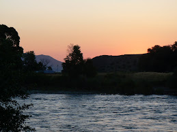
Louisiana is a rather small state and even at our snail's pace of about 150 miles a day, we could easily reach the Texas border in a day. Here's dawn on my birthday.


Of all the gifts I could possibly think of getting on my birthday, being greeted with a sky like this is among the best.


We'll let you amble through Louisiana with us so you can see the changing terrain.


By the time we reach Texas, it is noticeably drier. The trees are shorter and the grass is taller and brown. The majestic loblolly pines with their long soft-looking needles disappear and a shorter scrubbier pine takes it place. There is more openness, fewer heavily wooded area. Our destination is Livingston, Texas, which I think of as the southern counterpart to my hometown of Livingston, Montana. We will settle in here and greet 2009.

Tomorrow will be a new year !

Sunday, December 28, 2008

The Natchez Trace

After a great holiday visit with my family in Jackson, Mississippi, it was time for this Vagabond and her Wandering Wonder Dog to move along their way.

We set out on a sunny Sunday after solving various problems that come into life from time to time. A low tire that just happened. A cell phone that didn't survive being laundered. A wonder dog that likes the beds in a bricks and sticks house better than the one in the RV!

Today, we took the Natchez Trace Parkway from Jackson southwest to Natchez. The parkway is a lovely road that winds through the rural terrain, past cypress swamps, planted fields, and forests, ending up at the Mississippi River. I especially liked travelling it because it has little traffic, a low speedlimit, and, best of all, beautiful scenery!

The Natchez Trace is one of the oldest known roadways on this continent. It probably began as a game trail as buffalo, elk and deer moved north along it to salt licks in Tennessee. Then it became a footpath for Native Americans as they moved from place to place or travelled to trade with one another. Just look at that Mississippi sky they walked under!

Thomas Jefferson expanded it into "The Columbian Highway" and it fostered the development of settlements along the way. On an earlier visit, my son took me to see the old wagon train ruts that still endure in a few places today.

The Trace ran from Memphis in the north down to Natchez, on the Mississippi, in the south.

At Natchez, we found the delightful little "Natchez State Park," which was our home for the night.

As you can see, at this time of year state park campgrounds are not very full, especially on weekdays. There were a very few other campers here. Since we were only staying one night, we took advantage of a "pull through' site, which means that I didn't have to unhitch the car and back in, I could just pull out in the morning with my little Toad still hooked up behind.

Natchez State Park is arranged around Natchez Lake.

Would you believe that the largest of the large mouth bass ever caught in Mississippi was caught in this lake? I know that my brother-in-law Gene, back in Wyoming, would just love to be out on that lake with his fishin' pole! The bass, by the way, weighed over 18 lbs.

While visiting in Jackson, I stayed in two different campgrounds, having been flooded out of the first one. Both were very nice, but city lights and noises surrounded them. Here, back in a state park away from the city, it is quiet and dark. I love the peacefulness and it settles my soul. The stars are amazing. One day I will learn how to take pictures of night skies to share them with you.

Today was a good day.

Sunday, November 16, 2008

The Mounds People -- Ka-Do-Ha Indian Village

Since it was too rainy today to look for diamonds, Chorro and I drove over to the nearby Ka-Do-Ha Indian Village, a settlement of Caddo Indian people that existed about a thousand years ago.


Chorro had to wait in the car, but there were three small dogs outside that reminded him of his cousins back in Wyoming, so he was content to sit there and talk with them a bit while I toured the museum and site.


The tribe who inhabited this village was stable with an agricultural society. They lived in huts and grew corn, beans and pumpkins, similarly to the Anasazi who lived to the west about the same time. The Caddo Indians here also hunted buffalo, a fact determined from excavating the village. The diorama below is dark and a little out-of-focus, but it shows how the village might have looked, based on what remains. There is a round hut in the foreground and the mounds at the center, back, towards the left. The funny little white things in the upper half of the picture are clouds. Aren't they cute? The indistinct stuff on each side is a reflection on the glass in front of the diorama.

Many beautiful artifacts were unearthed in ecavating these mounds. These are excellently made points.

And the pottery is beautiful.


This pictures shows actual mounds. To the right, the mound i(with the shelter on it) is a burial site for chiefs or important persons in the village. To the left, the mound is a ceremonial site.


Under the shelter is this excavation of the site. The bones and artifacts are replicas, not the real thing. Their placement represents where the actual items were found. An interesting note was that this male, about 50, had arthritis, as can be determined from the size of his knees. There were two burial excavations at this mound.


This mound is a ceremonial site. It held a structure that represented, perhaps, a temple, in which there was a continuously burning fire. When the current chief of the village died, the temple was burned and a new one contstructed on top of it. Thus the mound. The burial mound was different in that it held only two separate graves and they were not on top of each other. Other unexcavated mounds in the area were presumably also burial sites.


I think it is fascinating to find these advanced civilizations of "savages" in the history of this land. I'm still puzzling about the Northern Europeans who slaughtered ruthlessly to "own" the land, which is a strange concept in itself.

Back at the car, Chorro sat uncomfortably while a little shaggy blonde dog who could have passed for Chorro's little brother was barking loudly at him on the outside. I don't know what kind of claims Chorro made on the little guy's territory, but he chased us barking waaaaayy down the lane.

So ended another good day.

Saturday, November 15, 2008

Some days are diamonds . . .

There is one diamond mine in the world that is open to the public and where you can keep any diamonds you find and I'm there!


Crater of Diamonds State Park in southwestern Arkansas has a real diamond mine, or actually, a field of diamonds.


In fact, it is the eighth-largest diamond mine in the world. Most days, someone finds a diamond. Yesterday, only one was found. The day before, five were. Some have been large, most are small.

The "mine" is thirty-some acres of plowed up field. It is the site of a volcano that erupted about 1,000,000 years ago, bringing to the surface some of the hardened carbon stuff created eons before that. "Mining" is searching most any way you want that doesn't use motorized equipment. Shovels, buckets, screens and sluice boxes are all fine if you want to go that route. Admission is $6.50 per day and there were about 20-30 people searching today. I think in the summer the number is probably ten times that.


Of course I spent the day looking for a diamond too. At first I was excited to see sparkles in the muddy soil and thought there must be diamond flakes all over. Nope, the sparkly flakes were mica. The diamonds found here can be white, brown or yellow, so that made looking even more interesting.

It has rained hard. "They" say that is the best time to find diamonds because some are newly uncovered by the rain. I walked uphill in the mud and soon could hardly lift my feet!


Can you see the huge clump of mud sticking to my foot? The only thing worse than that is to have huge clumps of mud sticking to both feet.


All of the mud in the lower half of the picture that is surrounding my feet was stuck to them. Two huge clods! I spent a lot of time keeping my feet clean enough to lift to take another step forward in the field.

Years ago, a shaft was dug hoping to find the source of the diamonds, but apparently the diamonds were dislodged from deep in the earth and only those on the surface can be discovered.
As I was walking leaving the are this afternoon, an older gentleman was just entering and he looked at me and said, "Have you seen Jack Nicholson's 'The Bucket List'?" I said I had and he said, "Well, this is on mine."

Here was my find. None of them were diamonds.


Here was another find, beautiful in yellow, orange, purple and pink.


John Denver sang, "Some days are diamonds, some days are stone."

Today was a diamond.

Friday, November 14, 2008

Arkansas, we are here!

We've decided Arkansas is the Golden State (sorry California). At least in the autumn. We drove the golden-orange roads today heading for our first state park in Arkansas. I will tell you what park it is tomorrow.


We're in the woods here rather than by a lake. And this is lovely too. The trees are tall oaks and loblolly pines, so looking around we see both gold and green. Here's our little woodsy nest for a couple of nights.


It happened that there was a charming nature trail down to the river where I could take Chorro off his leash and let him run. Here he is doing his happy dance.


Doesn't it make you wonder if grandmother's house will be through these woods?


Well here's the river! This is the Little Missouri River. There are actually two Little Missouri Rivers. One flows in North and South Dakota and Wyoming. The other is here in Arkansas. Here, it is referred to as Little Mo.


This community of ducks lives on Little Mo.


There was a small squabble in this community, but it was shortly worked out.


On the way back from the river, we came upon this moss. What a perfect color and texture for my next living room carpet!


Sunset in the woods is hardly noticeable. But as dusk comes, campfires light up all around us. The crickets chirp loudly, and it is warm enough that I have an open window and let them sing me to sleep.

Today was a good day.

Monday, November 10, 2008

Raymond Gary Lake

We drove south through a lot of Oklahoma today, along the Indian Turnpike.

We saw miles of rolling hills and no towns, few farms and not much traffic along the way.

Raymond Gary is the name of a small state park in the lower east corner of Oklahoma and we totally loved it. It was quiet, away from traffic, towns, noise and shared with just a few other people. It had the most beautiful lake we've been camped on this fall and the camping sites were right next to the water. Heavenly.


We quickly found a campsite and just started taking pictures.


Chorro wanted to explore the water

So I let him go in and check it out. Brrr. This is too chilly!

But the ducks love it.

And I think we have another blue heron who has found his winter home.

Sunset was another golden pastel water color.

Chorro waited patiently for the night life,

but all that happened out here was that dusk settled in.

Later, we could see the reflection of dock lights from the other side of the lake.

In the morning, the mist on the lake is eerily beautiful.


and watch the mist disappear


as the sun comes out and brightens the lake.

I could just sit here and take in the reflection of the trees on the still water, in fact, that is just what I did. I couldn't get enough of it!

We walked the shoreline, saw fishing jumping in the lake, a few fisher folks on the shore, and lots of blue sky.


Doesn't this look like a snug spot?

It was.

Today was a good day.